

View count:
1662
Land Use Plan
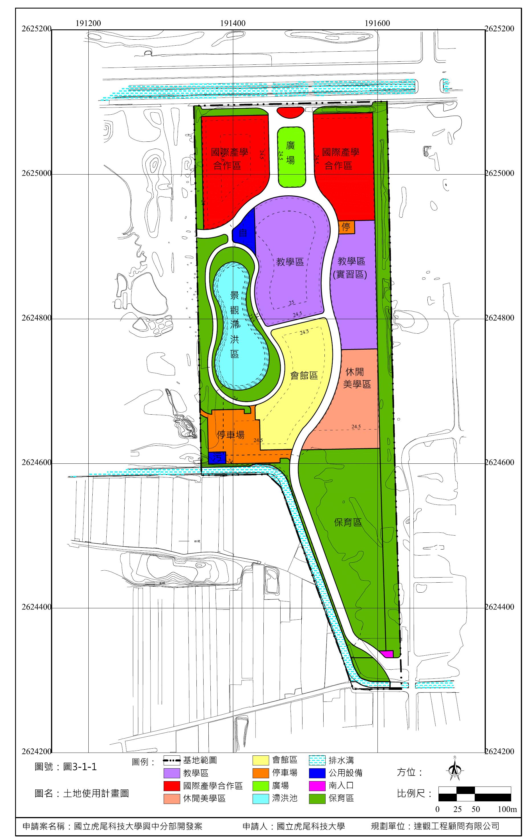
Land Use Plan (Figure 3-1-1) — Detailed Description
Project Name: National Formosa University Xingzhong Branch Development Project. Applicant: National Formosa University. Planning Unit: Fengguan Engineering Consultants Co., Ltd. Scale: 0–25–50–100m.
This diagram uses color coding to indicate the location of each zone. Legend details are as follows:
- Purple: Teaching Area (including Teaching Area Practice Zone)
- Red: International Industry-Academia Cooperation Zone (one on each side of the northern end of the site)
- Orange: Leisure Aesthetics Zone (southeast)
- Yellow: Conference Hall Zone (central-south)
- Dark orange: Parking Area (southwest)
- Green: Plaza (north-center)
- Cyan: Detention Pond (west)
- Dark green: Conservation Area (southern elongated strip)
- Pink: South Entrance
- Blue: Public Facilities
- Cyan-blue dashed line: Drainage Ditch
- Black dashed line: Site Boundary
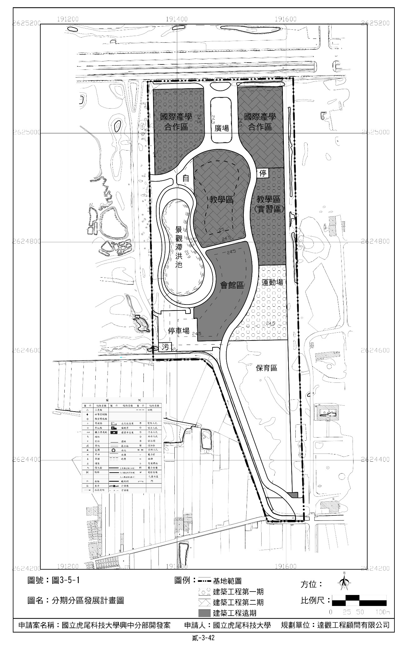
Phased Zone Development Plan (Figure 3-5-1) — Detailed Description
Project Name: National Formosa University Xingzhong Branch Development Project. Applicant: National Formosa University. Planning Unit: Fengguan Engineering Consultants Co., Ltd. Scale: 0–25–50–100m.
This diagram uses different fill patterns to indicate the construction scope of each phase. Legend details are as follows:
- Black dashed line: Site Boundary
- Dotted pattern: Phase 1 Construction (International Industry-Academia Cooperation Zone, Teaching Area Practice Zone)
- Hatched pattern: Phase 2 Construction (Teaching Area, Conference Hall Zone)
- Dark grey solid fill: Long-term Construction (Parking Area)
Zone locations are described as follows:
- Northern end, left and right: International Industry-Academia Cooperation Zone (Phase 1)
- North-center: Plaza
- West: Landscape Detention Pond
- Center: Teaching Area (Phase 2)
- East: Teaching Area Practice Zone (Phase 1)
- Central-south: Conference Hall Zone (Phase 2)
- Southeast: Sports Field
- Southwest: Parking Area (Long-term)
- Southern end: Conservation Area
- Southwest corner: Sewage Treatment Plant
- West: Water Supply Land
← Return to Phased Zone Development Plan image (opens in a new window)
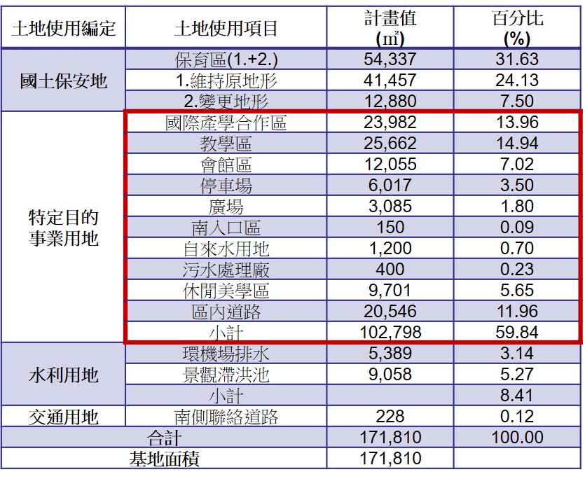
Land Usage Table — Detailed Description
| Land Use Designation | Land Use Item | Planned Area (m²) | Percentage (%) |
|---|---|---|---|
| National Land Conservation Zone | Conservation Area (1.+2.) | 54,337 | 31.63 |
| 1. Maintain Original Terrain | 41,457 | 24.13 | |
| 2. Modified Terrain | 12,880 | 7.50 | |
| Special Purpose Business Land | International Industry-Academia Cooperation Zone | 23,982 | 13.96 |
| Teaching Area | 25,662 | 14.94 | |
| Conference Hall Zone | 12,055 | 7.02 | |
| Parking Area | 6,017 | 3.50 | |
| Plaza | 3,085 | 1.80 | |
| South Entrance Zone | 150 | 0.09 | |
| Water Supply Land | 1,200 | 0.70 | |
| Sewage Treatment Plant | 400 | 0.23 | |
| Leisure Aesthetics Zone | 9,701 | 5.65 | |
| Internal Roads | 20,546 | 11.96 | |
| Subtotal | 102,798 | 59.84 | |
| Water Conservancy Land | Airport Perimeter Drainage | 5,389 | 3.14 |
| Landscape Detention Pond | 9,058 | 5.27 | |
| Subtotal | 8.41 | ||
| Transportation Land | South Connecting Road | 228 | 0.12 |
| Total | 171,810 | 100.00 | |
| Site Area | 171,810 | ||